
A Plan of the Intended Canal from Chesterfield, by...


Sail: Planos
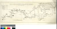
Izenburua: A Plan of the Intended Canal from Chesterfield, by Retford, to the River Trent [Material cartográfico] : Also Alterations therein as proposed by John Grundy, Engineer, extracted from Mr. Varley's Plan Views & Observations made on the Premises / as proposed by Mr. Brindley
Autorea: Brindley, James, 1716-1772
Datu-area: Escala [ca. 1:66500]
Argitalpena: [London] : Engraved by T. Jefferys Geographer to the King, 1770
Deskribapen fisikoa: 1 map. ; 28 x 75 cm
Oharrak: Escala gráfica de 5 millas [= 12,1 cm]
Orografía de perfil
Consta una tabla con datos referentes a las dimensiones y capacidad de los tramos en que se divide el canal
Forma parte de la Colección Mendoza
Materia / lugar / evento: Trent (Gran Bretaña, Río)
Inglaterra - Canales - Mapas
Inglaterra - S. XVIII - Mapas
Nottinghamshire - Canales - S. XVIII - Mapas
Derbyshire - Canales - S. XVIII - Mapas
Canal de Chesterfield - S. XVIII - Proyectos
Tokiaren izen hierarkikoa: Gran Bretaña - Inglaterra
Otros autores: Jefferys, Thomas, ca. 1710-1771
Grundy , John
Varley, John , Senior
Bigarren mailako izenburuak: DERBYSHIRE (Reino Unido) (Inglaterra). Canales. 1:66500 (1770)
CDU: 912:626.13(083.9)(420)"1770"
420 Derbyshire, Condado
42 Nottinghamshire, Condado
Argitalpen mota:
 Mapak
Mapak
Derechos: