
A New Map of the Netherlands or Low Countries : with the...


Sail: Mapak
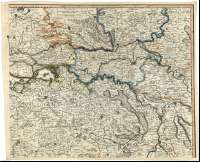
Izenburua: A New Map of the Netherlands or Low Countries : with the South part of the Provinces of Holland, Utrecht & Gelders and the whole of Zeeland [Mapa]
Datu-area: Escala [ca. 1:257000]
Argitalpena: London : Published by Laurie & Whittle, N°53 Fleet Street, 12th. May 1794
Deskribapen fisikoa: 1 map. en 4 h. : col. ; 97 x 118 cm en h. de 49 x 59 cm o menor
Oharrak: Escalas gráficas de 15 millas inglesas [= 9,4 cm], 6 leguas comunes franceas [= 10,3 cm], 2 1/2 millas alemanas [= 7,2 cm] y 3 "Houres Journeys" [= 6,3 cm]. Coordenadas referidas a un meridiano que no se especifica (E 22°12'--E 26°28'/N 52°03'). Red geográfica de 5' en 5'
Orografía de perfil
Indica bajos en algunos puntos de la costa
Límites administrativos diferenciados por color
Tabla de signos convencionales para indicar ciudades, castillos, monasterios y fuertes
Título enmarcado en cartela decorada con elementos vegetales y personajes alegóricos, y coronada por ángeles trompeteros
Inserta en el ángulo superior izquierdo una escena del sitio de una ciudadamurallada, blanco del fuego de la artillería
Materia / lugar / evento: Mapas generales
Divisiones administrativas
Países Bajos
Otros autores: Laurie and Whittle (Londres)
Bigarren mailako izenburuak: BELGICA. Mapas generales. 1:257000 (1794)
CDU: 912:(1-2/-5)(492-13)(493)"1794"
492-13
493
Argitalpen mota:
 Mapak
Mapak
Derechos: