
A New Travelling Map. of the Country Round London,...


Sail: Mapak
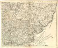
Izenburua: A New Travelling Map. of the Country Round London, Extending from North to South 190 Miles, and from East to West 159 Miles : On which are Deliniated from an Actual Survey, all the Turnpike & Principal Cross Roads (with the Distances from Place to Place according to the Mile Stones) Cities, Market Towns, Churches, Rivers, Remarkable Hills, Noblemens & Gentlemens Seats and the Sea Coast of the British Channel from Lowestoft to Weymouth [Mapa] / by Jno. Andrews and A. Dury ; Compiled & Drawn by John Andrews
Autorea: Andrews, John, 1736-1809
Datu-area: Escala [ca. 1:250000]
Argitalpena: London : Publish'd according to Act of Parliament... by R. Sayer & J. Bennett Map & Printsellers N 53 Fleet Stret,..., Jany 1, 1779
Deskribapen fisikoa: 1 map. en 4 h. : col. ; 99 x 122 cm. en h. de 53 x 64 cm
Oharrak: Comprende la zona suroriental de Inglaterra
Escala gráfica de 30 millas estatutarias inglesas de 69 1/2 al grado [= 19,2 cm]. Coordenadas referidas al meridiano de Londres (O 2°30'--E 1°54]/N 52°30'--N 50°17'). Red geográfica de 30' en 30'. Orientada con lis en rosa de ocho vientos
Orografía de perfil. Indica bancos y bajos
Límites entre los condados diferenciados por colores
En el ángulo inferior izquierdo nota relativa a la distancia de grados entre Saint Pauls y Bristol en el año 1761
Indica en los márgenes el nombre de los condados que no aparecen representados en su totalidad
Materia / lugar / evento: Mapas generales
Divisiones administrativas
Otros autores: Dury, Andrew, 1742-1778
Sayer and Bennett (Londres)
Bigarren mailako izenburuak: INGLATERRA (Reino Unido). SE. Mapas generales. 1:250000 (1779)
CDU: 912:(1-37)(420-12)"1779"
420-12
Argitalpen mota:
 Mapak
Mapak
Derechos: