
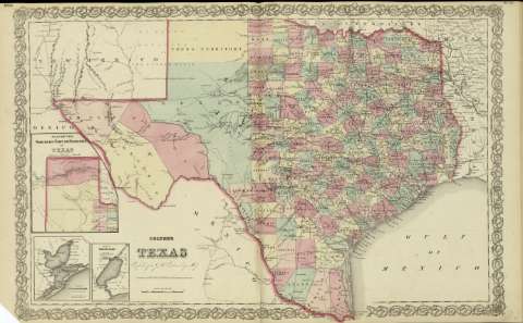
Plan of Galveston Bay : from the U.S. Coast Survey


Sail: Planos
Izenburua: Plan of Galveston Bay : from the U.S. Coast Survey
Autorea: Colton, George Woolworth, 1827-1901
Datu-area: Escala [ca. 1:1.028.806], 10 nautical miles [= 1'8 cm]
Argitalpena: New York : published by G.W. and C.B. Colton & Co., [1872]
Deskribapen fisikoa: 1 mapa ; 9 x 8 cm, en h. de 44 x 36 cm
Oharrak: Inserto en: Colton's Texas.
Con: Plan of the northern part or Panhandle of Texas ; Plan of Sabine Lake.
Erregistro erlazionatuak: En: Colton's General Atlas : containing one hundred and eighty steel plate maps and plans, on one hundred and nineteen imperial folio sheets. - New York : published by G.W. and C.B. Colton & Co. n 172 William St., [1872]. - Nº 56
Materia / lugar / evento: Mapas físicos
Galveston (Estados Unidos, Bahía) - Cartas náuticas
Tokiaren izen hierarkikoa: Estados Unidos - Texas
Otros autores: Estados Unidos. Coast Survey
G.W. & C.B. Colton & Co.
Bigarren mailako izenburuak: GALVESTON (Estados Unidos) (Texas) (Bahía). Mapas físicos. 1:1028806 (1872)
CDU: 912:911.2(26.04 Calveston)(764)'1872'
764 Calveston
26.04 Calveston
Argitalpen mota:
 Mapak
Mapak
Derechos: