
A Map of the Northern Part of the Lake Winandermere and...


Sección: Mapas
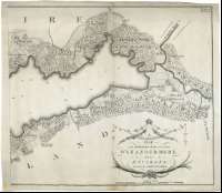
Título: A Map of the Northern Part of the Lake Winandermere and its environs [Mapa] / Surveyed by James Clarke ; Engraved by Samuel John Neele 352 Strand London
Autor: Clark, James, m. 1790
Área de datos: Escala [ca. 1:10000]
Publicación: Penrith : Published by James Clarke, Feby. 10, 1787
Descripción física: 1 map. en 2 h. ; 47 x 107 cm, en h. de 50 x 60 cm o menor
Notas: Escala gráfica de 80 "Chains" [= 16,7 cm]. Orientado con lis en rosas de cuatro vientos
Indica sondas batimétrics
Destaca los principales caminos y núcleos de población
En el ángulo superior derecho : "Plate 10"
Título y autor en cartela decorada con guirnaldas
Forma parte de la Colección Mendoza
Materia / lugar / evento: Batimetría
Núcleos de población
Caminos
Cumbria
Inglaterra
Otros autores: Neele, Samuel John, 1758-1824
Títulos secundarios: WINANDERMERE (Reino Unido). Inglaterra. (Lago), septentrional. Batimetría. 1787. 1:10000
CDU: 912:551.46+314+625.7(420:285.2)"1787"
420:285.2 Winandermere-17
Tipo de publicación:
 Mapas
Mapas
Derechos: