
The Counties of Fife and Kinross with the Rivers Forth...


Sección: Mapas
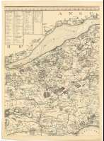
Título: The Counties of Fife and Kinross with the Rivers Forth and Tay [Mapa] / Survey'd & Engraved by John Ainslie
Autor: Ainslie, John, 1745-1828
Área de datos: Escala [ca. 1:64000]
Publicación: Edinburgh : Publish'd according to Act of Parliament [andd] Printed for the Author, June 20 th. 1775
Descripción física: 1 map. en 6 h. : col. ; 102 x 122 cm en h. de 57 x 47 cm o menor
Notas: Carta arrumbada que comprende la actual región de Fife
Escalas gráficas de 7 millas estatuarias y 6 millas geográficas [= 17,5 cm]. Coordenadas referidas al meridiano de Edimburgo (O 0°33'00"--E 0°38'30"/n 56°29'00"--N 55°55'00"). Recuadro geográfico de 1' en 1'. Orientado con tres lises en rosa de dieciseis vientos
Orografía por normales
Indica sondas batimétricas, veriles, bajos, fondeaderos y bancos de arena
Divisiones administrativas diferenciadas por color
Tabla de medición de distancias expresada en millas
Tabla de signos convencionales para indicar la categoría de los núcleos depoblación, carreteras, etc.
Título y autor en escena con ruinas góticas
Forma parte de la Colección Mendoza
Inserta : "Plan of Cupar". Escala [ca. 1:3000], 3 chains [ 1,9 cm]. Orientado con lis en rosa de cuatro vientos. "Plan of St. Andrews". Escala [ca. 1:3000], 4 chains [2,5 cm]. Orientado con lis en rosa de 4 vientos
Materia / lugar / evento: Mapas generales
Planos de población
Divisiones administrativas
Kinross (Reino Unido) (Escocia)
Fife (Reino Unido)
Escocia
Tay (Reino Unido) (Escocia) (Río)
Forth (Reino Unido) (Río)
Cupar
Saint Andrews (Reino Unido) (Escocia) (Fife) (Ciudad)
Otros autores: Ainslie, John, 1745-1828
Títulos secundarios: FIFE (Reino Unido) (Escocia). Mapas generales. 1:64000 (1775)
CDU: 912:551.46+[314(084.3)]+528.01(1-2/-5)(411:282:242)
411 Fife, región
410:282.242 Forth
411:282.242 Tay
Tipo de publicación:
 Mapas
Mapas
Derechos: