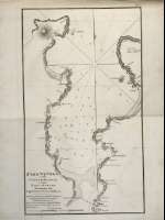
Port Vivero on the Coast of Galicia in the Bay of Biscay
Sección: Mapas
Título: Port Vivero on the Coast of Galicia in the Bay of Biscay [Material cartográfico] / Surveyed by Brigadier Don Vincent Tofiño
Área de datos: Escala ca. 1:15.605. 1 Maritim Mile =8,9 cm
Publicación: London : Published by W. Faden, geographer to His Majesty, and to His Royal Highness the Prince Regent, 1812
Descripción física: 1 mapa ; 27 x 35 cm
Materia / lugar / evento: Puerto de Vivero - S. XIX
Vivero (España, Ría)
Género / forma: Cartas náuticas
Nombre jerárquico lugar: España - Galicia - Lugo - Vivero
Otros autores: Faden, William, 1750-1836
Dougall, John, 1760-1822, trad.
Títulos secundarios: Vivero (España, Ría). 1:15605
CDU: 460
Tipo de publicación:
![]() Mapas
Mapas
Derechos: CC BY. Esta licencia permite utilizar las obras siempre que se mencione la fuente de procedencia
© Ministerio de Cultura


