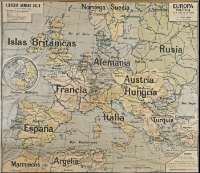
Europa política


-
Section: Maps
Title: Europa política [Material cartográfico] / por P. Vidal de la Blache, y R. Torres Campos
Author: Vidal de la Blache, Paul, 1845-1918
Área de datos: Escala 1. 3.500.000
Publication: Paris : Librería Armand Colin, [s.a.]
Physical description: 1 mapa : col., montado sobre tela ; 90 x 105 cm
Series: (Colección de mapas murales)
Notes: Referencias: Ortega Cantero, Nicolás. "El modelo de la geografía francesa y la modernización de la geografía española (1875-1936)". Ería, n. 61, 2003, pp.149-158
Relieve representado por sombreado. - Dibujados meridianos y paralelos formando una cuadrícula
Fechas deducidas del periodo de colaboración de ambos autores
Inserta: 1. [Mapa de localización de Europa en el mundo]. - 18 cm de diám.Materia / lugar / evento: Europa - Mapas políticos - 1889-1904
Hierarchical place name: Francia - París
Otros autores: Torres Campos, Rafael, 1853-1904
Vidal de la Blache, Paul, 1845-1918
Armand Colin (Firma) Títulos secundarios: Europa. Mapas políticos. ca. 1900
Serie secundaria: Armand Colin (Firma). Colección de mapas murales
Type of publication:
 Maps
Maps
Derechos:
Cardenal Cisneros Secondary School (Madrid)Colección: Gabinete Geografía e Historia — Signature: Col. Mapas 20, Baldas 5-6 — Notes: Este mapa corresponde al nuevo n. 50