
The Dutch Colony of the Cape of Good Hope


Section: Maps
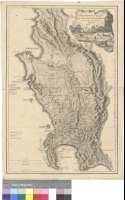
Title: The Dutch Colony of the Cape of Good Hope [Material cartográfico] / By L.S. de la Rochette MDCCLXXXII ; Engraved by W. Faden
Área de datos: Escala [ca. 1:530000]
Publication: London : Published by W. Faden, Successor to the late T. Jefferys Geogrr. to the King, Charing Cross, March 20th. 1782
Physical description: 1 map. ; 50 x 33 cm
Notes: Mapa de la antigua colonia alemana en la parte suroccidental de la actual Sudáfrica, comprendiendo desde el cabo de Buena Esperanza hasta la bahía de Lamberts, y desde la cordillera Olifants hasta la costa atlántica
Escalas gráficas de 6 millas alemanas [= 8,4 cm], 30 millas inglesas [= 9,1 cm] y 8 leguas náuticas [= 8,4 cm]. Coordenadas referidas al meridiano de Londres (E 17°45'--E 19°32'/S 32°07'-S 34°25')
Orografía de perfil. Sondas batimétricas
Relación de los principales accidentes geográficos indicados por clave alfabética
Título rodeado por una escena sobre la caza de elefantes. Tres de estos animales aparecen representados sobre el mapa
Materia / lugar / evento: Cabo de Buena Esperanza - S. XVIII - Mapas
Países Bajos - Colonias - S. XVIII - Mapas
Género / forma: Mapas físicos
Hierarchical place name: Sudáfrica - Ciudad del Cabo Cabo de Buena Esperanza
Otros autores: Faden, William, 1750-1836
Títulos secundarios: SUDAFRICA. Suroccidental. Mapas generales. 1782. 1:530000
UDC: 912(620-14)"1782"
620-14
Type of publication:
 Maps
Maps
Derechos: