
Indien & Inner-Asien in 2 blättern im massstabe von 1...


Section: Maps
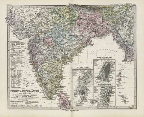
Title: Indien & Inner-Asien in 2 blättern im massstabe von 1:7500000 : [generalkarte] / Von A. Petermann ; bearbeitet von E. Debes & H. Habenich
Área de datos: 1:17500000 (E 70 50'-E 97 20'/N 48 00'-N 6 00')
Publication: Gotha [Alemania, R.D.] : Justus Perthes, 1879
Physical description: 1 mapa en 2 h. : col. ; 33 x 41 cm en h. de 39 x 48 cm, pleg. en 39 x 24 cm
Notes: Coordenadas referidas a los meridianos de París y de Hierro
Relieve representado por normales
Leyenda de signos utilizados
Inserta: Calcutta und Umgebung [Karte]. 1:150000 ; Madras und Umgebung. 1:150000 ; Die insel Bombay. 1:150000 ; Point de Galle. 1:150000
Registros relacionados: En: Hand atlas : über alle Theile der Erde und über das Weltgebäude. - Gotha [Alemania R.D.] : Justus Perthes, [1879]. - N. 63, 64
Materia / lugar / evento: Mapas generales
Calcuta (India)
Bombay (India)
India
China
Tibet (China)
Sri Lanka
Asia
Hierarchical place name: India
India - Calcuta
India - Bombay
China
China - Tibet
Sri Lanka
Otros autores: Debes, Ernst, 1840-1923
Habenicht, Hermann, (1844-1917
Perthes, Justus, 1749-1816
Títulos secundarios: Asia. 1:7500000
UDC: 912:341.222(548.7+515+540+510)'1842'
540
548.7
515
510
Type of publication:
 Maps
Maps
Derechos: