
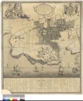
A Plan of the Town and Citadel of Plymouth


Section: Planos
Title: A Plan of the Town and Citadel of Plymouth [Material cartográfico] / Surveyed by Richard Cowl, 1778
Author: Cowl, Richard, S. XVIII
Área de datos: Escala [ca. 1:2900]
Publication: London : Printed for William Faden , 1780
Physical description: 1 plan. ; 84 x 73 cm
Notes: Dedicatoria : "To his Royal Highnefs George Augustus Frederick, Prince of Wales... This Plan of the Town and Citadel of Plymouth is most humbly Inscribed by His Royal Highness's Most dutiful servant Richd. Cowl"
Escala gráfica de 600 pies [= 7 cm]. Orientado con lis en rosa de ocho vientos
Orografía a trazos
Relación de los edificios, clles y plazas más significativos de la ciudad, indicados por clave alfanumérica, reseñando el equivalente entre los nombres modernos y antiguos
Dedicatoria enmarcada en cartela barroca
Decorado con el escudo de armas de la familia real británica, una escena mitológica y varias figuras de navíos
Forma parte de la Colección Mendoza
Materia / lugar / evento: Plymouth (Inglaterra) - S. XVIII - Mapas
Género / forma: Planos de población
Hierarchical place name: Gran Bretaña - Plymouth
Otros autores: Faden, William, 1750-1836
Títulos secundarios: PLYMOUTH (Reino Unido) (Inglaterra). Planos de población. 1780. 1:2900 (1778)
UDC: 912:[314(084.3)](420)"1778"
420 Plymouth
Type of publication:
 Maps
Maps
Derechos: