
Plan topographique du Défilé de Pancorbo


Section: Planos
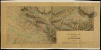
Title: Plan topographique du Défilé de Pancorbo
Área de datos: Escala [ca. 1:10.000]. 1.000 toesas [= 19,4 cm]
Publication: [S.l. : s.n., 18--?]
Physical description: 1 plano : ms., col., papel vegetal ; 42 x 91,2 cm
Notes: Comprende parte de los términos municipales de Pancorvo y Ameyugo en la provincia de Burgos
Orientado al norte geográfico
Relieve representado por sombreado
Aparece trazada una retícula que permite la localización de cualquier punto del área representada
Documento relacionado con: "Plan topographique de la partie de la Grande route de Bayonne á Madrid", de sig. SG. Ar.M-T.1-C.4(1), y con los de sig. SG. Ar.M-T.1-C.4-47(3),(4),(5), que completan este itinerario hasta Hernani
Materia / lugar / evento: Pancorvo (Burgos)
Ameyugo (Burgos)
Hierarchical place name: España - Castilla y León - Burgos - Ameyugo
España - Castilla y León - Burgos - Pancorvo
Títulos secundarios: AMEYUGO (Burgos). 1:10.000
UDC: (460.182 Ameyuco)
Type of publication:
 Maps
Maps
Derechos: