
The Travellers Guide being the best Mapp of the Kingdom...


Section: Maps
Title: The Travellers Guide being the best Mapp of the Kingdom of England and Principalaty of Wales : Whereim are Delineated 3000 Towns & Villages more then in any Mapp yet Extent besides ye Notations of Bridges & Rivers &c. To which is added ye Direct and cross Roads according to Mr. Ogilby's late Survey [Mapa] / Described by C. Saxton and now carefully Corrected with new Additions. By Phillip Lea
Author: Saxton, Christopher, 1543-1610
Área de datos: Escala [ca. 1:460000]
Publication: London : Printed for T. Bowles in St. Pauls Church Yard : & John Bowles & San in Cornhill, [1754-1763?]
Physical description: 1 map. en 20 h. : col. ; 137 x 175 cm, en h. de 30 x 48 cm
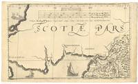
Notes: Comprende además las costas de la zona más meridional de Escocia, oriental de Irlanda e Irlanda del Norte y noroccidental de Francia
Dedicatoria : "To the Right Honourable and Right Reverend Father in God Peter Lord Bishop of Winchester Prelate of the most Noble Order of the Gart. &c. This Map of England Is humbly dedicated and presented"
Fecha de publicación deducida teniendo en cuenta el período en el que pudieron colaborar los editores
Escalas gráficas de 50 millas grandes [= 23 cm], 50 millas medianas [= 20'8 cm] y 50 millas pequeñas [= 19,1 cm]. Coordenadas referidas a un meridiano que no se especifica (E 15°17'--E 26°56'/N 55°52'--N 49°58'). Orientado con lis en dos rosas de treinta y dos vientos, presentando una de ellas la mención nominal de los puntos cardinales
Orografía de perfil
Líneas divisorias entre los condados diferenciados por color
Tabla de signos convencionales para indicar distintos tipos de población y carreteras, haciendo mención de las distancias que aparecen indicadas en el mapa entre ciudades
Relación de las principales ciudades indicando el condado al que pertenecen y sus coordenadas geográficas
Leyendas relativas a los reinados de Enrique II y III de Inglaterra y a características geográficas, económicas y de población
Adornado con barcos y monstruos marinos
Cartelas barrocas, enmarcando todos los datos que figuran en el documento, entre las que destacan la que recoje el título y la de la dedicatoria, al estar coronadas por los escudos de la Casa Real inglesa y del obispo de Winchester, respectivamente
Forma parte de la colección Mendoza
Materia / lugar / evento: Mapas generales
Historia
Divisiones administrativas
Núcleos de población
S.XVIII
Gales
Otros autores: Saxton, Christopher, 1543-1610
Lea, Philip, fl. 1683-1700
Bowles, Thomas , II, ca. 1695-1767
John Bowles and Son (Londres)
Títulos secundarios: INGLATERRA (Reino Unido). Mapas generales. 1:460000 (1754-1763?)
UDC: 912:314]+93+(1-35)(420)(429)"1754/1763"
420
429
Type of publication:
 Maps
Maps
Derechos: