
A Compleat Map of British Isles, & Great Britain and...


Section: Maps
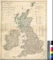
Title: A Compleat Map of British Isles, & Great Britain and Ireland : With their respective Roads and Divisions
Área de datos: Escala [ca. 1:2111000]
Publication: London : Publish'd by Laurie & Whittle, Fleet Street, as the Act directs, 12th. May 1794
Physical description: 1 mapa : col. ; 61 x 48 cm
Notes: Escalas gráficas de 80 millas estatutarias [= 6,1 cm], 60 millas escocesas de 50 en grado, 60 millas irlandesas y 25 leguas marítimas. Coordenadas referidas al meridiano de Londres (O 13°10'-E 4°10'/N 60°35'-N 49°35'). Red geográfica de 1° en 1°. Orientado con lis en rosa de cuatro vientos, inscrita en círculo
Relieve de perfil
Señala veriles, bajos y bancos
Relación de las divisiones administrativas indicada por clave cromática
Materia / lugar / evento: Mapas generales
Divisiones administrativas
Irlanda
Irlanda del Norte (Reino Unido)
Escocia
Gales
Inglaterra (Reino Unido)
Otros autores: Laurie and Whittle (Londres)
Títulos secundarios: REINO UNIDO. Mapas generales. 1:2111000 (1794)
UDC: 912:(1-35)(410)(417)"1794"
410
417
Type of publication:
 Maps
Maps
Derechos: