
Colton's Palestine


Section: Maps
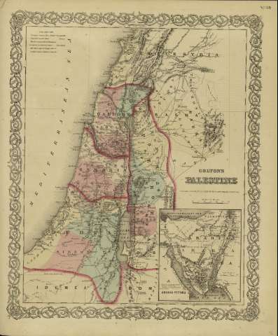
Title: Colton's Palestine / [drawn by George Woolworth Colton]
Author: Colton, George Woolworth, 1827-1901
Área de datos: Escala [ca. 1:1.207.728], 30 miles [= 4'6 cm] (E 34º--E 37º /N 34º--N 31º)
Publication: New York : published by G.W. and C.B. Colton & Co., [1872]
Physical description: 1 mapa : col. ; 44 x 36 cm
Notes: Indica meridianos de origen: Washington y Greenwich ; Márgenes graduados.
Indica divisiones administrativas marcadas por colores.
Inserta: Arabia Petraea.
Inserta nota: "Entered according to Act of Congress in the year 1855 by J.H. Colton & Co. in the Clerk's office of the district court for the southern district of New York".
Registros relacionados: En: Colton's General Atlas : containing one hundred and eighty steel plate maps and plans, on one hundred and nineteen imperial folio sheets. - New York : published by G.W. and C.B. Colton & Co. n 172 William St., [1872]. - Nº 119
Materia / lugar / evento: Geografía histórica
Galilea (Región Histórica) - Mapas
Samaria - Mapas
Judea - Mapas
Perea - Mapas
Palestina - S. XIX - Mapas
Otros autores: G.W. & C.B. Colton & Co.
Títulos secundarios: ORIENTE MEDIO. Geogragía histórica. 1872. 1:1207728
UDC: 912:913.1]:(569.3+569.4+569.5)
569.3
569.4
569.5
Type of publication:
 Maps
Maps
Derechos: