
Hertfordia comitatvs vernacule Hertfordshire.


Section: Maps
Title: Hertfordia comitatvs vernacule Hertfordshire. [Material cartográfico] / Joan Blaeu
Author: Blaeu, Joan, 1596-1673
Características de edición: cartógrafo
Área de datos: Escala indeterminada
Publicación, Producción, Distribución, etc.: Producción: Amsterdami : Apud Iohannem Blaeu, 1648?
Physical description: 1 mapa en 1 h : grab., col
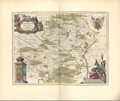
Notes: Incluye: Mapa del condado de Hertfordshire, que muestra colinas, ciudades, pueblos y aldeas, carreteras, ríos y otras características topográficas. Un blindaje en la parte superior derecha y un pilar arquitectónico en la parte inferior izquierda con cuatro blindados (dos en blanco).
Incluye: Título incluido en una cartela decorativa en la parte superior izquierda con campesinos haciendo una genuflexión.
Incluye: Una barra de escala decorativa en la parte inferior derecha con tres soldados, uno leyendo un mapa y los otros apoyados en sus alabardas.
Registros relacionados: En: Nuevo Atlas del Reyno de Inglaterra. - Amsterdami : Apud Iohannem Blaeu, 1648?
Materia / lugar / evento: Hertfordshire
Otros autores: Blaeu, Joan, 1596-1673, ed.
Títulos secundarios: Gran Bretaña. Mapas generales. 1648?
Type of publication:
 Maps
Maps
Derechos: