
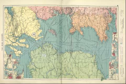
The Irish Channel


Section: Maps
Title: The Irish Channel [Material cartográfico]
Author: Philip, George
Área de datos: 1:1.500.000
Publication: [London] ; [Liverpool] : George Philip & Son, Ltd : The London Geographical Institute : Philip, Son & Nephew, [1922]
Physical description: 1 mapa ; 73 x 48 cm
Notes: Copia digital. Madrid : Ministerio de Cultura. Dirección General del Libro, Archivos y Bibliotecas, 2010
Inserta mapas de: Cork Harbour ; Cardiff ; Fishguard ; Swansea ; Barry ; Bristol ; Belfast ; The Clyde ; Dublin Bay ; Barrow
Registros relacionados: En: Philip's Mercantile Marine Atlas. - [London] : Edited by George Philip [et al.], 1922. - Mapa 6
Registros incluidos: Philip's Mercantile Marine Atlas . - [London] : Edited by George Philip [et al.], 1922
Materia / lugar / evento: Rutas marítimas - Mapas
Mar de Irlanda - Mapas
Género / forma: Cartas náuticas
Hierarchical place name: Mar de Irlanda
Irlanda
Gran Bretaña
Otros autores: George Philip & Son Ltd.
The London Geographical Institute
Merchant, Shippers, Exported and Ocean Travelles
Títulos secundarios: Mar de Irlanda. Mapas generales. ca. 1922
UDC: (261.274)
Type of publication:
 Maps
Maps
Derechos: