
Britischen Inseln und das Umliegende Meer im maassstabe...


Section: Maps
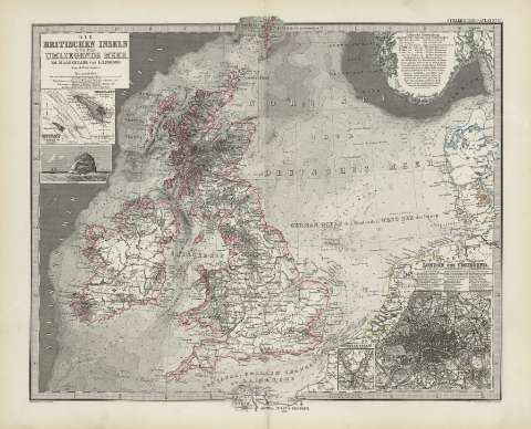
Title: Britischen Inseln und das Umliegende Meer im maassstabe von 1:3700000 die : [generalkarte] / Von A. Petermann ; bearbeitet von Ernst Debes ; gestahen v. Poppey u. stichart
Área de datos: Escala 1:3700000 (O11 -O12 /N60 -N49)
Publication: [Gotha [Alemania, R.D.] : [Justus Perthes], [1879]
Physical description: 1 mapa : col. ; 33x41 cm, en h. de 39x48 cm, pleg. en 39x24 cm
Notes: Constan ademas coordenadas según el meridiano de París y de Ferro
Relieve : líneas perpendiculares normales
Leyenda de signos utilizados
Inserta : Plano de población de 'London und Umgegend'. - Escala 1:150000 ; 'Helgoland' [karte]. - Escala 1:50000 ; 'Helgoland und die dune. - Escala 1:150000
Registros relacionados: En: Hand atlas : über alle Theile der Erde und über das Weltgebäude. - Gotha [Alemania R.D.] : Justus Perthes, [1879]. - N 45
Materia / lugar / evento: Londres (Reino Unido)
Reino Unido
Hierarchical place name: Gran Bretaña
Títulos secundarios: BRITANICAS (Islas). 1:3700000
UDC: 912:341.222(41-2/-5)'1879'
41
912:314(410 Londres)(084.3)'1879'
Type of publication:
 Maps
Maps
Derechos: