
Cary's new map of England and Wales with part of Scotland...


Section: Maps
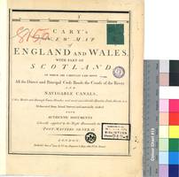
Title: Cary's new map of England and Wales with part of Scotland [Material cartográfico] : on which are carefully laid down all the direct and principal crofs roads, the course of rivers and navigable canals / Delineated from Actual Surveys; and materially assisted from Authentic Documents
Author: Cary, John, ca. 1754-1835
Área de datos: Escala ^ca. 1:317.635!. 30 British Statute Miles 60 1/2 to a Degree ^= 15,2 cm!
Publication: London : Engraver & Map seller, No. 181 Strand, June 11th 1794
Physical description: 1 atlas (85 p.) : 81 lám. col. ; 32 x 27 cm
Notes: Bajo el título: "Cities, Market and Borough Towns, Parishes, and most considerable Hamlets, Parks, Forest"
Orientado con lis
Relieve representado por normales
Tabla de signos convencionales para indicar núcleos de población, estaciones, caminos y puertos
Incluye índices
lám. 6. ^Isle of Wight! - lám. 7-8. ^The English Channel! - lám. 9. ^Costa francesa! - lám. 10. Scilly Isles - lám. 11. ^Cornwal y Devon! - lám. 12. ^Devon y Somerset! - lám. 13. Somerset, Devon y Dorset! - lám. 14. ^Somerset, Wilt, Dorset y Hamp! - lám.15. ^Hamp e Isla Wight! - lám. 16. ^Surrey y Sussex! - lám. 17. ^Kent! - lám. 18. Straits of Dover - lám. 19. St. Brides Bay - lám. 20. ^Pembroke! - lám. 21. ^Caermarthen y Glamorgan! - lám. 22. ^Breckock y Monmouth, Canal de Bristol! - lám. 23. ^Gloucester y Wilt! - lám. 24. ^Oxford, Berk y Buckingham! - lám. 25. ^Hertford y Middlesex! - lám. 26. Essex! - lám. 27. ^Essx y Kent! - lám. 28. ^Canal de San Jorge! - lám. 29. Cardigan Bay - lám. 30. ^Cardigan, Montgomery, Radnor y Breckn! - lám. 31. ^Shrop y Hereford! - lám. 32. ^Worcester, Statford y Warwick! - lám. 33. ^Leicester, Warwick y Orthampton! - lám. 34. ^Rutland, Orthampton, Cambrige, Huntingdon y Bedord! - lám. 35-36. ^Norfolk y Sutfolk! - lám. 37. ^Costa y Canal de Irlanda! - lám. 38. Caernarvon Bay - lám. 39. ^Angle Sea, Caernarvon, Merioneth y Denbigh! - lám. 40. ^Flint, Denbigh, Chester y Statford! - lám. 41. ^Chester y Statford! - lám. 42. ^Derby y Nottingham! - lám. 43. ^Lincoln! - lám. 44-45. ^Mar de Alemania y Costa de Norfolk! - lám. 46. ^Mar de Irlanda! - lám. 47. ^Mar de Irlanda con las con parte de la Isla de Man y la Costa Inglesa! - lám. 48. ^Mar de Irlanda! - lám. 49. ^Lancaster! - lám. 50. ^Lancaster y York! - lám. 51-52. ^York y la Costa con el Mar de Alemania! - lám. 53-54. ^Mar de Alemania! - lám. 55. ^Irlanda! - lám. 56. ^Luce Bay e Isla de Man! - lám. 57. ^Costa de Shie y Cumberland! - lám. 58. ^Cumberland y Westmoreland! - lám. 59. ^Durham yYorkshire! - lám. 60. ^Costa de Durham y York! - lám. 61. ^Costa de York! - lám. 62. General Map - lám. 63. ^Escala! - lám. 64. ^Costa Este de Irlanda del Norte y la Isla de Arran en Escocia! - lám. 65. ^Ayrshire y la Isla de Arran! - lám. 66-67. ^Escocia del Sur! - lám. 68-69. ^Northumberland, en el Mar del Norte! - lám. 70-71. ^Mar del Norte! - lám. 72. Explanations - lám. 73. ^Costa de Argyllshire y la Isla de Islay! - lám. 74. ^Argyllshire! - lám. 75. ^Esccocia del sur! - lám. 76. ^Escocia del Sur: Edimburgh! - lám. 77. ^Costa Sureste de Escocia! - lám. 78-81. ^Mar!
Materia / lugar / evento: Gran Bretaña - S. XVIII - Mapas
Hierarchical place name: Gran Bretaña
Otros autores: Cary, John, ca. 1754-1835
Títulos secundarios: GALES (Reino Unido). Mapas generales. 1:317635 (1613)
ESCOCIA (Reino Unido). Mapas generales. 1:317635 (1613)
INGLATERRA (Reino Unido). Mapas generales. 1:317635 (1613)
UDC: 420
411
429
Type of publication:
 Maps
Maps
Derechos: