
Bacon's Large-Print map of South Africa


Section: Maps
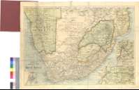
Title: Bacon's Large-Print map of South Africa [Material cartográfico]
Author: G.W. Bacon & Co. (Londres)
Edición: 10th Edition
Área de datos: [Ca. 1:3500000] (E 13°30'-E 36°00'/S 19°45'-S 35°00')
Publication: London : G.W. Bacon & Co. Ltd, 127, Strand, [188-?]
Physical description: 1 mapa : col. ; 50 x 71 cm, pleg en 20 x 12 cm + 1 carpetilla
Notes: Presenta colonias inglesas, portuguesas y alemanas establecidas en el sur de Africa entre los paralelos 20 y 35 S
Fecha de publicación deducida teniendo en cuenta los años en que la firma Bacon & Co., trabaja en la dirección indicada
Escala gráfica de 100 millas inglesas [= 4,7 cm]. Red geográfica de 2° en 2°
Relieve representado por normales
Originalmente plegado y preservado en forma de cuadernillo, en cuya cubierta se indica el número de edición
Inserta: Laing's nek & Vicinity. Escala [ca. 1:1600000], 70 millas [= 7,15 cm]. Detalle de la región de Natal entre los paralelos 27° y 29° S. ; Mafeking to Pretoria. Escala [ca. 1:1600000], 100 millas [= 10,05 cm]. Coordenadas referidas al meridiano de Greenwich (E 25 -E 28°/S 25°-S 27°). Detalle parcial de la zona de Pretoria ; Durban & Port Natal. Escala [ca. 1:200000], 3 millas inglesas [= 2,4 cm]
Materia / lugar / evento: Colonialismo
África - S. XIX - Mapas
Género / forma: Mapas políticos
Hierarchical place name: África meridional
Otros autores: Bacon, G. W. (George Washington), 1830-1921
Títulos secundarios: AFRICA. S. Colonias. 1:350000 (188-?)
UDC: 912:325.45(6-13)"188"
6-13
Type of publication:
 Maps
Maps
Derechos: