
The Western Coast of Africa : From Cape Blanco to Cape...


Section: Maps
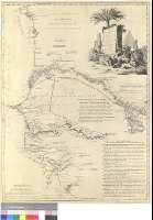
Title: The Western Coast of Africa [Material cartográfico]: From Cape Blanco to Cape Visrga, eshibiting Senegambia proper / by T. Jefferys, Geographer to his Majesty
Author: Jefferys, Thomas, ca. 1710-1771
Área de datos: Escala [ca. 1:1900000]
Publication: London : Printed by Robt. Sayer, N°53 Fleet Street, 1789
Physical description: 1 mapa : col. ; 69 x 51 cm
Notes: Escalas gráficas de 25 leguas inglesas de veinte al grado [= 7,4 cm] y 100 millas estatutarias inglesas de sesenta y nueve y medio al grado [= 8,6 cm]. Coordenadas referidas a los meridianos de Ferro (E 0°00'--E 9°10'/N 20°50'--N 9°00') y Londres (O 17°30'--O 8°55')- Recuadro geográfico de 1° en 1°
Orografía de perfil
Indica sondas batimétricas y veriles a lo largo de toda la línea costera y sobre las aguas del río Gambia
Fronteras entre los distintos reinados y territorios diferenciadas por colores
Consta una relación detallada sobre los establecimientos ingleses en los ríos Senegal y Gambia en 1730
Título enmarcado en cartela decorada con la figura de un indígena, y especies animales y vegetales del continente
En esquina inferior izquierda: This map is copied from an Original Drawn by Mons. D'Anville...
Materia / lugar / evento: Africa noroccidental - Divisiones territoriales - S. XVIII - Mapas
Género / forma: Mapas administrativos
Hierarchical place name: África noroccidental
Títulos secundarios: MAURITANIA. Occidental. Divisiones administrativas. 1789. 1:1900000
UDC: 912:551.46+(1-4)(661.2-15)(663-15)(665.1)(665.7)(665.2-15)"1789"
661.2-15
663-15
665.1
665.7
665.2-15
Type of publication:
 Maps
Maps
Derechos: