
A New and Accurate Plan of the Ancient Borough of Bury...


Section: Maps
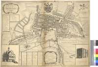
Title: A New and Accurate Plan of the Ancient Borough of Bury Saint Edmunds in the County of Suffolk [Material cartográfico] / By Alexander Downing ; W.H. Toms Sculpt
Author: Downing, Alex
Área de datos: Escala [ca. 1:3200]
Publication: [United Kingdom] : Published by the Propietor Alexander Downing, 1741
Physical description: 1 plan. ; 53 x 71 cm
Notes: Dedicatoria : "To the Right Worshipful the Alderman, Recorder, Capital Burgefses, and Common Council, o the Borough of Bury St. Edmunds, in the County of Sufolk This Plan is humbly Inscribed, by their Worships most humble Servant Alex Downing"
En margen inferior : "Alex. Downing Delin."
Escala gráfica de 20 chains de Gunter o un cuarto de milla [= 12,6 cm]. Orientado con lis en rosa de treinta y dos vientos
Orografía a trazos
Relación de las princiaples calles y callejuelas, puertas y edificios de la ciudad, indicados por clave alfanumérica
Constan los vendedores del mapa : "Sold by Saml. Watson Bookseller at Bury, and W.H. Toms Engraver in Union Court neer Hatton Garden, Holborn"
Continuación del mapa fuera de los márgenes
Título y dedicatoria enmarcados en sendas cartelas rococó. Figura el escudo de la ciudad y los símbolos de los poderes civil y religioso
Forma parte de la Colección Mendoza
Inserta prespectivas de dos edificios de la ciudad: "The Cross". "Abbey Gate"
Materia / lugar / evento: Divisiones territoriales
Suffolk (Condado) - S. XVIII - Mapas
Otros autores: Toms, William Henry, fl. 1723-1758
Títulos secundarios: BURY SAINT EDMUNDS (Reino Unido) (Inglaterra). Planos de población. 1741. 1:3200 (1740)
UDC: 912:[314(04.3)]+721:744.4(420)"1741"
420 Bury Saint Edmunds
Type of publication:
 Maps
Maps
Derechos: