
Plan of the City of Norwich : Describing the Streets,...


Section: Planos
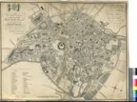
Title: Plan of the City of Norwich [Material cartográfico] : Describing the Streets, Lanes, Public Edificies & Buildings &c. : Divided Into its respective Words / Survey'd by Anthony Hochstetter ; Engraved by Samuel John Neele, No. 352, Strand, London
Author: Hochstetter, Anthony
Área de datos: Escala [ca. 1:3400]
Publication: Norwich : Published... by AHochstetter, 1789
Physical description: 1 plan. ; 60 x 77 cm
Notes: Dedicatoria : "To the Right Worshipful the Mayor, Recorder Sheriffs, Aldermen, and Comonalty the City of Norwich, this Plan is humbly dedicated By their most obedient humble Servant Anthony Hochsetter, Land-Surveyor"
Escala gráfica de 19 chains o 76 varas [= 11,8 cm]. Orientado con lis en rosa de ocho vientos prolongados
Orografía a trazos
Relación de los principales edificios públicos y religiosos de la ciudad, así como de los distritos en que se divide, indicados por clave alfanumérica
Vendido por "B. Beatniffe Messrs. Berry, Crouse & Stevenson, Norwich ; Downes & March, Yarmoth ; & by the Engraver, London"
Consta el precio de este ejemplar
Sobre la dedicatoria, figura el escudo de la ciudad sotenido por dos figuras alegóricas
Forma parte de la Colección Mendoza
Materia / lugar / evento: Planos de población
Distritos
Norwich - S. XVIII - Mapas
Norfolk (Reino Unido) (Condado) - S. XVIII - Mapas
Otros autores: Neele, Samuel John, 1758-1824
Títulos secundarios: NORWICH (Reino Unido) (Inglaterra). Planos de población. 1:3400 (1789)
UDC: 912:[314(084.3)]:(1-250)(420)"1789"
420 Norwich
Type of publication:
 Maps
Maps
Derechos: