
Bowles's New Pocket Map of Switzerland, comprehending the...


Section: Maps
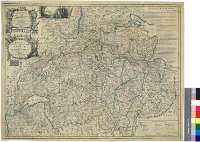
Title: Bowles's New Pocket Map of Switzerland, comprehending the Thirteen Cantons with their Allies & Subjected Territories [Mapa] / by Abr. Rouvier = Bowles's Nouveau Carte de Poche de Suisse ou front Les Treize Cantosn, Leurs Allies et Sujets / par Abr. Rouvier
Author: Rouvier, Abr., S. XVIII-S. XIX
Área de datos: Escala [ca. 1:530000]
Publication: London = a Londre : Printed for the Propietor Carington Bowles, No. 69 in St. Pauls Church Yard,... = Imprimee pour la Propietaire Carington Bowles, dans la Cimetiere...., [1764-1793?]
Physical description: 1 map. : col. ; 51 x 67 cm
Notes: Fecha deducida teniendo en cuenta la actividad editora de Carington Bowles
Escala gráfica de 12 leguas comunes suizas de 24 al grado [= 10,45 cm]. Coordenads referidas al meridiano de Ferro (E 23°15'--E 27°58'/N 48°05'--N 45°45'). Red geográfica de 15' en 15'
Orografía escenográfica
Líneas divisorias entre los cantones diferenciadas por colores
Tabla de signos convencionales para indicar los distintos tipos de población, la religión que profesan, carreteras, distintas divisiones administrativas, batallas, fuertes y accidentes geográficos más significativos
Nota relativa a la división en cantones y zonas dependientes de los mismo, así como sus fuerzas militares
Adornado con una escena de juegos típicos de la época
Títulos enmarcados en cartelas decoradas con motivos bélicos y escudos de los cantones
Forma parte de la Colección Mendoza
Materia / lugar / evento: Mapas generales
Divisiones administrativas
Otros autores: Bowles, Carrington
Títulos secundarios: SUIZA. Mapas generales. 1764-1793?. 1:530000
UDC: 912:(1-359)(494)"1764/1793"
494
Type of publication:
 Maps
Maps
Derechos: