
Bowles's New Pocket Map of Great Britain and Irland :...


Section: Maps
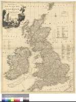
Title: Bowles's New Pocket Map of Great Britain and Irland : delineated from the latest Surveys
Área de datos: Escala [ca. 1:1860000]
Publication: London : Printed for & Sold by the Propietor Carington Bowles, No. 69 in St. Pauls Church Yard... Published as the Act directs, 2d. Jan. 1790
Physical description: 1 mapa : col. ; 67 x 53 cm
Notes: Escalas gráficas de 90 millas estatutarias inglesas [= 7,8 cm], 65 millas escocesas comunes [= 6,5 cm] y 40 millas irlandesas [= 4,45 cm]. Coordenadas referidas al meridiano de Londres (O 12°55'-E 4°30'/N 60°25'-N 49°35'). Red geográfica de 1° en 1°. Orientado con lis en rosa de ocho vientos
Indica bancos y bajos
Señala mediante color los límites entre los condados y marca los derroteros a seguir entre los puertos ingleses y los puertos del continente
Relación de cada uno de los condados indicada por clave numérica
Tabla de signos convencionales referentes a distintos tipos de ciudades y carreteras
Título enmarcado en cartela decorada con una vista de una bahía
Forma parte de la Colección Mendoza
Materia / lugar / evento: Mapas generales
Divisiones administrativas
Derroteros
Puertos
Carreteras
Irlanda
Inglaterra (Reino Unido)
Gales
Escocia
Otros autores: Bowles, Carrington
Títulos secundarios: REINO UNIDO. Mapas generales. 1:1860000 (1790)
UDC: 912:527.6(1-35)(41)"1790"
41
Type of publication:
 Maps
Maps
Derechos: