
Bowles's New Pocket Map of Scotland, laid down from the...


Section: Maps
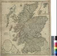
Title: Bowles's New Pocket Map of Scotland, laid down from the original survey of James Dorret, Geographer : with the addition of New Roads ands other Modern Improvements from the best Authorities [Mapa]
Área de datos: Escala [ca. 1:890000]
Publication: London : Printed for the Proprietors Bowles & Carver, No. 69 in St. Pauls Church Yard, Publish'd as the Act directs, 2 Jan, 1794
Physical description: 1 map. : col. ; 55 x 51 cm
Notes: Escalas gráficas de 50 millas inglesas de 69 1/2 al grado [= 9 cm] y 30 millas escocesas de 50 al grado [= 7,5 cm]. Coordenadas referids al meridiano de Londres (O 8°45'--O 0°55'/N 58°55'--N 54°35'). Red geográfica de 1° en 1°. Orientado con lis en rosa de ocho vientos
Orografía de perfil
Diferencia con color las líneas divisorias entre los antiguos condados que conformaban Escocia
Leyenda explicativa sobre los diferentes tipos de población y carreteras
Forma parte de la Colección Mendoza
Inserta : "Shire of Orkney". Escala [ca. 1:2010000], 70 millas inglesas [= 5,6 cm]
Materia / lugar / evento: Mapas generales
Divisiones administrativas
Otros autores: Dorret, James, fl. 1744-1761
Bowles and Carver
Títulos secundarios: ESCOCIA (Reino Unido). Mapas generales. 1:890000 (1794)
UDC: 912:(1-35)(411)"1794"
411
Type of publication:
 Maps
Maps
Derechos: