
Bowles's New Topographical Chart of the English Channel...


Section: Maps
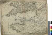
Title: Bowles's New Topographical Chart of the English Channel with it's Environs : Comprehending the Southern Counties of England & Wales, with the Maritime Provinces of France Flanders, & Zeeland, from Helveotsluys, to the River Loire, and the Island Country to Paris [Mapa]
Área de datos: Escala [ca. 1:1230000]
Publication: London : Printed for the Propietor Carington Bowles, No. 69 in St. Pauls Church Yard Publish'd as the Act directs, 2 Mar. 1780
Physical description: 1 map. : col. ; 49 x 68 cm
Notes: Escala hallada a partir de un grado de latitud [= 9 cm]. Coordenadas referidas al meridiano de Londres (O 7°15'--E 4°10'/N 52°20'--N 47°10'). Orientado con lis en rosa de dieciséis vientos, en el que se señala además la variación magnética observada
Carta arrumbada en la que se indican sondas batimétricas expresadas en estdios ingleses, bajos, bancos, veriles y dirección de las corrientes
Diferencia con color las líneas que delimitan las divisiones administrativas de los paises representados
Forma parte de la Colección Mendoza
Materia / lugar / evento: Mapas generales
Divisiones administrativas
Francia
Bélgica
Inglaterra (Reino Unido)
Gales
Otros autores: Bowles, Carrington
Títulos secundarios: LA MANCHA (Canal). Cartas náuticas. 1:1230000 (1780)
UDC: 912:551.46]+(1-35)(420:26.06)(44:26.06)(429-13)(493-15)
420:26.06 La Mancha
44:26.06 La Mancha
429-13
493-15
Type of publication:
 Maps
Maps
Derechos: