
Bowles's New Pocket Map of the ten Catholick Provinces of...


Section: Maps
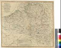
Title: Bowles's New Pocket Map of the ten Catholick Provinces of the Lower Countries, or Netherlands [Mapa] / by J. Palairet, Geographer, lately Revised and Improved from from [sic] the Original Map of Tob Mayer, Published at Nuremberg
Author: Palairet, Jean, 1697-1774
Área de datos: Escala [ca. 1:633000]
Publication: London : Printed for the Propietor Carington Bowles, N°69 in St. Pauls Church Yard, [1775-1780?]
Physical description: 1 map. : col. ; 46 x 53 cm
Notes: Presenta la zona comprendida entre las ciudades de Beauvais, Thionville, Emmerick y Brielle
Fecha de publicación tomada del "Tooley's Dictionary of Mapmakers", Tring, 1979, p. 486
Escala gráfica de 10 millas comunes de Alemania de 15 al grado [= 11,7 cm], 60 millas estatuarias de 60 4/25 al grado [= 10,6 cm] y 16 leguas de Flandes de 24 al grado [= 11,2 cm]. Coordenadas referidas al meridiano de Ferro (O 19°27'--O 24°24'/N 51°50'--N 49°13'). Red geográfica de 1° en 1°. Mención nominal de los puntos cardinales
Destaca, mediante líneas de diferente color, las divisiones entre los condados y ducados, diferenciándose a su vez, los límites de los territorios de los mismos pertenecientes a Francia, Austria y Holanda, confirmada por una relación de dichas demarcaciones y sus países soberanos
Materia / lugar / evento: Mapas generales
Divisiones administrativas
S.XVIII
Luxemburgo
Francia
Países Bajos
Otros autores: Bowles, Carrington
Títulos secundarios: BELGICA. Mapas generales. 1:633000 (1775-1780?)
UDC: 912:(1-2/-5)(493)(442)(492-13)"1775/1780"
493
442
492-13
Type of publication:
 Maps
Maps
Derechos: