
A plan of the city and suburbs of Dublin, with the...


Section: Planos
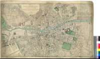
Title: A plan of the city and suburbs of Dublin, with the Division of their parishes / Geometrically Surveyed by Jo. Rocque Topographer to his Majesty ; with Additions and Improvements by Mr. Bernard Scalé to 1787
Author: Rocque, John, fl. 1734-1762
Área de datos: Escala [ca. 1:5300]
Publication: London : Printed for Robt. Sayer ; Map & Printseller N°53 in Fleet Street..., 1st. Jany. 1787
Physical description: 1 map. : col. ; 48 x 81 cm
Notes: Escalas gráficas de 200 toesas francesas [= 7,4 cm], 2 estadios de 1/4 de milla, equivalentes a 440 yardas, 50 pérticas irlandesas y 60 pérticas inglesas
Orografía por normales
Destaca los límites entre las distintas parroquias urbanas
Indica la toponimia de las calles, plazas, parques y edificios mas relevantes
Sobre el curso del río Liffey, figuran representaciones de varias embarcaciones de vela
Impreso en varios colores
Materia / lugar / evento: Planos de población
Distritos
Leinster (Irlanda)
Otros autores: Scalé, Bernard, fl.1760-1787
Títulos secundarios: DUBLIN (Irlanda) (Leinster). Planos de población. 1:5300 (1787)
UDC: 912:[314(084.3)]:(1-250)(417)"1787"
417 Dublín
Type of publication:
 Maps
Maps
Derechos: