
Bowle's new four-sheet map of Europe : divided into it's...


Section: Maps
Title: Bowle's new four-sheet map of Europe : divided into it's Empires, Kingdoms, States, Republiks and Principalities / laid down from surveys and observations of the most celebrated Geographers ; corrected from late Remarks with many Additions and valuable Modern Improvements
Edición: Corrected 1794
Área de datos: Escala [ca. 1:3318000]
Publication: London : Printed for the Propietors Bowles & Carver, N° 69 St. Pauls Chuch Yard, 1794
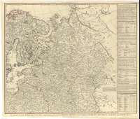
Physical description: 1 map. en 4 h. : col. ; 98 x 102 cm, en h. de 54 x 63 cm
Notes: Fecha de publicación más antígua de las que aparecen en el documento : "1785"
Escalas gráficas de 200 millas estatutarias [= 9,7 cm], 200 millas geográficas, 200 millas turcas, 90 leguas marinas, 110 leguas francesas y 300 verstas. Coordenadas referidas al meridiano de Londres (E 25°--O 70° N 70°--N 30°). Orientado con lis en rosa de ocho vientos. Red geográfica de 5° en 5°
Orografía de perfil
Fronteras diferenciadas por colores
Título enmarcado en cartela decorada con motivos militares y mitológicos
En los márgenes derecho e izquierdo, flanqueando el mapa, aparecen varias tablas con datos estadísticos sobre cada uno de los estados europeos
Materia / lugar / evento: Mapas generales
Divisiones administrativas
Otros autores: Bowles and Carver
Títulos secundarios: Europa. Mapas generales. 1:3318000 (1794)
UDC: 912:(1-4)(4) "1794"
Type of publication:
 Maps
Maps
Derechos: