
The world : Index chart of Admiralty sailing directions


Section: Maps
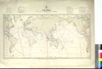
Title: The world : Index chart of Admiralty sailing directions [Mapa] / The Admiralty ; H.M. Stationery Office
Área de datos: Escala [ca. 1:65000000] ; proy. Mercator (O 180°--E 180°/N 75°--S 65°)
Publication: Londres : The Admiralty, 1926
Physical description: 1 map. ; 36 x 70 cm
Notes: Escala aproximada hallada a partir de la medición de un arco de meridiano terrestre de un grado
Incluye índice numérico de las diversas zonas marítimas en que aparece distribuido el mapamundi
Nota explicativa sobre las características y extensión de algunos volúmenes
División posterior en áreas geográficas diferentes con numeración propia, realizada a mano
Representa escudo de la "Oficina hidrográfica", con la leyenda : "precio un chelin"
Materia / lugar / evento: Mapas índices
Otros autores: Gran Bretaña. Hydrographic Department
Títulos secundarios: Mundo. Mapas índice. 1926. 1:65000000
UDC: 912(083.86)]:551.46(100)"1926"
100
Type of publication:
 Maps
Maps
Derechos: