
A Topographical Map of the County of Berks


Section: Maps
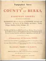
Title: A Topographical Map of the County of Berks [Mapa] / By John Rocque, Topographer to his Majesty = Carte Topographique de le Comte de Berks / Par Jean Rocque, Topographe de Sa Majesté Britannique ; L. F. Deharme Sculpt ; Benning Sculp
Author: Rocque, John, fl. 1734-1762
Área de datos: Escala [ca. 1:32000]
Publication: London : Publish'd According to Act of Parliament by John Rocque, 1761
Physical description: 1 map. en 18 h. : col. ; 160 x 273 cm, en h. de 66 x 52 cm o menos + + informe (13 p.: 50 cm)
Notes: Comprende los actuales condados de Berkshire y la parte suroccidental de Oxford
Dedicatoria : "To His Sacred Majesty George the third, this survey of Berkshire
Escalas gráficas de 3 millas [= 14,9 cm], 900 "perches", 5000 "yardas" y una legua común de 25 en grado. Coordenadas referidas al meridiano de la iglesia de San Pablo (O 1°37'--O 0°22'/N 51°49'--N 51°18'). Recuadro geográfico de 1' en 1'. Orientado con lis en nudo de cuatro rumbos y mención nominal de puntos cardinales. Consta el grado de declinación magnética
Orografía por normales
Divisiones administrativas diferenciadas por colores
Tabla con una lista de las parroquias con sus medidas y localización en el mapa
Dedicatoria y parte de las escalas inscritos en escena con alegorías a la monarquía y a la sabiduría realizada por S. Wale y A. Walker
Material anejo : "A Topographical Survey of the County of Berks in eighteen sheets... / by J. Rocque, Topographer to His Majesty". London : Printed for and sold by the Author..., 1761 (Printed by James Dixwell, in St. Martin's-Lane, near Charing-Cross). Contiene un índice de las posesiones de nobleza, lugares históricos, etc.
Forma parte de la Colección Mendoza
Inserta : "A Plan of Reading". Escala [ca. 1:11000], 800 yardas y 150 "perches" [= 6,7 cm]. Nota sobre la historia de Reading. Parte del condado de Berkshire
Materia / lugar / evento: Berkshire
Reading (Reino Unido)
Inglaterra (Reino Unido)
Otros autores: Dixwell, James, fl. 1761-1776
Deharme, L. F., FL. 1736-1766
Benning, Robert, fl. ca.1745-1766
Wale, Samuel, ca. 1721 1786
Títulos secundarios: BERKSHIRE (Reino Unido) (Inglaterra). Mapas generales. 1:32000 (1761)
UDC: 912:314(084-3)]+(1-2/-5)(420)"1761"
420 Berkshire, condado
420 Reading
Type of publication:
 Maps
Maps
Derechos: