
An Accurate Map of Great Britain, France & Ferol &...


Section: Maps
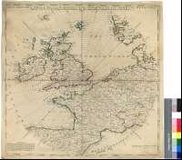
Title: An Accurate Map of Great Britain, France & Ferol & Ireland, with Part of Spain, Germany, Denmark & Shewing at One View the True Bearing and Horizontal Distanc of any Place within 700 Miles of London [Mapa] / Drawn from the Best Authorities
Área de datos: Escala [ca. 1:5420000]
Publication: [London : s.n., 18--?]
Physical description: 1 map. : col. ; 51 x 52 cm
Notes: Comprende además los Países Bajos, Suiza, parte de Italia septentrional y de Noruega meridional
Escala calculada a partir de un grado de latitud [= 2,05 cm]. Coordenadas referidas al meridiano de Londres (O 12°20'--E 12°00'/N 63°40'--N 39°30'). Mención nominal de los puntos cardinales
Representa un diagrama de círculos concétricos y radios, tomando como centro la ciudad de Londres, en el que los primeros indican las distancias (equidistantes 20 millas) y los segundos las direcciones
Nota explicando que el motivo de levantar este mapa fue conocer las distancias respecto a puntos fuera del Reino Unido
Fronteras entre los países diferenciadas por color
Forma parte de la Colección Mendoza
Materia / lugar / evento: Mapas generales
Divisiones administrativas
Títulos secundarios: EUROPA. O. Mapas generales. 1:5420000 (18)
UDC: 912:528.021(1-4)(4-15)"18"
4-15
Type of publication:
 Maps
Maps
Derechos: