
Nottinghamshire : Survey'd in 1774


Section: Maps
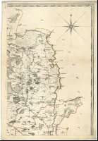
Title: Nottinghamshire : Survey'd in 1774 [Mapa] / by John Chapman
Author: Chapman, John
Edición: Second Edition, corrected
Área de datos: Escala [ca. 1:64500]
Publication: London : Printed for W. Faden Geographer to the King, Charing C ross, April 12th. 1792
Physical description: 1 map. en 4 h. : col. ; 127 x 84 cm, en h. de 67 x 47 cm
Notes: Dedicatoria : "To the Revd. Dr. Richard Kaye, Rector of Kirby in this County, Prebendery of York and Southwell... this Map undertaken by his Direction is Inscribed by his most faithfull humble Servant Ino. Chapman"
Escalas gráficas de 5 millas estatutarias [= 12,5 cm] y 5 millas geográficas [= 14,5 cm]. Coordenadas referidas al meridiano de Londres (O 1°22'35''--O 0°34'39''/N 53°33'20''--N 52°49'46''). Recuadro geográfico de 5' en 5'. Orientado con lis en rosa de dieciseis vientos
Orografía a trazos
Límites entre las divisiones administrativas (hundreds) diferenciados por color
Tabla de signos convencionales para indicar las ciudades con mercado, municipios, iglesias y capillas, carreteras, canales, etc.
Título enmarcado por paisaje, dedicatoria por cartela de guirnaldas coronada por escudo y encuadrada en paisaje, con edificio religioso al fondo, y tabla de signos convencionales enmarcada por cartela de guirnaldas
Materia / lugar / evento: Mapas topográficos
Divisiones administrativas
Otros autores: Faden, William, 1750-1836
Títulos secundarios: NOTTINGHAMSHIRE (Reino Unido) (Inglaterra). Mapas topográficos. 1792. 1:64500 (1774)
UDC: 912:(1-37)(420)"1774"
420, Nottinghamshire, condado
Type of publication:
 Maps
Maps
Derechos: