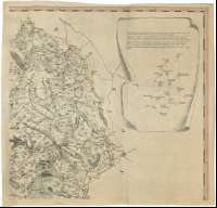
A map of the County of Stafford : From an Actual Survey...
Section: Maps
Title: A map of the County of Stafford : From an Actual Survey Begun in the Year 1769, and Finished in 1775 [Mapa] / By William Yates ; Engraved by John Chapman
Author: Yates, William, 1738-1802
Área de datos: Escala [ca. 1:65000]
Publication: [S.l. : s.n.], November the 7th. 1775
Physical description: 1 map. en 6 h. : col. ; 149 x 102 cm en h. de 54 x 54 cm
Notes: Dedicatoria : "To the Nobility, Gentry and Clergy, of the County of Stafford, this Map is Respectfully Inscribed, by their Obedient Humble Servant William Yates"
Escala gráficas de 6 millas estatutarias [= 14,8 cm] y 6 millas geográficas de 60 al grado [= 17,2 cm]. Coordenadas referidas al meridiano de Londres (O 2°28'00''--O 1°28'00''/N 53°13'26''--N 52°23'00''). Recuadro geográfico de 5' en 5'. Orientado con lis en rosa de ocho vientos prolongados
Orografía a trazos
Límites entre las divisiones administrativas diferenciados por colores
Tabla de signos convencionales para indicar las ciudades y pueblos, franjas y haciendas, caminos y canales etc.
Inserta en cartucho, nota y dibujo explicativo de las triangulaciones geodésicas realizadas como base para el levantamiento del mapa
En nota : "Sold by I. Chapman, at the Royal Academy Pall Mall, London. Thos. Yates, at Stowe, Staffordshire & by the Author at the Custom House Leverpool"
Título enmaracado por paisaje rural
Materia / lugar / evento: Mapas topográficos
Triangulaciones
Divisiones administrativas
S.XVIII
Inglaterra
Otros autores: Chapman, John
Títulos secundarios: STAFFORDSHIRE (Reino Unido) (Inglaterra). Mapas topográficos. 1775. 1:65000 (1769-1775)
UDC: 912:528.41:(1-37)(420)"1769/1775"
420 Stafford, condado
Type of publication:
![]() Maps
Maps
Derechos: CC BY. Esta licencia permite utilizar las obras siempre que se mencione la fuente de procedencia
© Ministry of Culture


