
Plano del sitio de Tarragona. Año 1811


Section: Planos
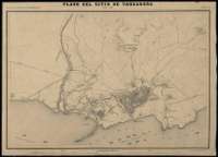
Title: Plano del sitio de Tarragona. Año 1811
Área de datos: Escala 1:10.000
Publication: [Madrid] : Lit. del Depósito de la Guerra, [1869-1901]
Physical description: 1 plano : montado sobre tela ; 31 x 46 cm
Notes: Comprende la ciudad de Tarragona y parte de sus alrededores, hasta una distancia aproximada de 1,5 km
Escala también dada en forma gráfica de 1/4 de legua
Relieve representado por curvas de nivel equidistantes 10 metros
Indica la disposición de la flota inglesa, los nombres de los fuertes y las posiciones ocupadas por las tropas beligerantes, cada una de las cuales se halla identificada con un número, sin que sin embargo exista la clave explicativa de los mismos
Existe otro ejemplar
Pertenece al: "Atlas de la Guerra de la Independencia". Lámina 32
Materia / lugar / evento: Fortificaciones
Tarragona
Hierarchical place name: España - Cataluña - Tarragona - Tarragona
Otros autores: España. Depósito de la Guerra
Títulos secundarios: TARRAGONA. Estrategia militar. 1869-1901. 1:10.000 (1811)
UDC: 912:355.43+[314(084.3)]:623.1(467.141.5-2)"1811"
467.141.5-2
Type of publication:
 Maps
Maps
Derechos: