
Nouvelle Castille Province de la Manche


Section: Maps
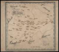
Title: Nouvelle Castille Province de la Manche
Área de datos: Escala [ca. 1:620.000]. 7 [leguas geográficas] [= 7,1 ; cm]
Publication: [S.l. : s.n., 1809]
Physical description: 1 mapa : ms., col., montado sobre tela ; 39,9 x 45,4 cm
Notes: Comprende aproximadamente la actual provincia de Ciudad Real y la parte occidental de la de Albacete, representado únicamente los núcleos de población con más entidad
Fecha tomada del catálogo del SGE: "Castilla la Nueva. Provincias de Toledo, Ciudad Real, Cuenca y Guadalajara. Siglos XVII a XIX", p. 221
Coordenadas referidas al meridiano de Tenerife [E 11º55'-E 14º35'/N 39º55'-N 37º55'] Recuadro geográfico de 15' en 15'. Manuscrito coloreado a la acuarela en varios colores
Materia / lugar / evento: Mapas generales
Ciudad Real
Albacete
Murcia
Hierarchical place name: España - Murcia
España - Castilla-La Mancha - Ciudad Real
España - Castilla-La Mancha - Albacete
Títulos secundarios: CASTILLA-LA MANCHA. 1:620.000
UDC: 912:314+(1-2/-5)(464.3)(467.42-15)"1809"
464.3
467.42-15
Type of publication:
 Maps
Maps
Derechos: