
Plan of Ciudad Rodrigo, describing its Siege by the...


Section: Planos
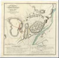
Title: Plan of Ciudad Rodrigo, describing its Siege by the Allied Army 1812 General the Earl of Wellington Commander in Chief : By Permission of the Quarter Master General / Neele Sculpt
Author: Neele, Samuel John, 1758-1824
Área de datos: Escala [ca. 1:5.900]. 500 yardas [=7,7 cm]
Publication: [London] : Published by W. Faden, Geographer to His Majesty an d to His Royal Highness the Prince Regent, Charing Cross, June 4th. 1812
Physical description: 1 plano : col. ; 38 x 38 cm
Notes: Comprende la ciudad y sus alrededores
Relieve representado por normales
Señala las posiciones ocupadas por el ejército sitiador
Relación de las principales puertas y edificios de la ciudad, indicada por clave numérica
Explicación de las distintas fases del ataque a la ciudad, desarrollado entre los días 7 y 19 de enero
Relación de las obras realizadas por franceses e ingleses para reducir la ciudad indicada mediante clave cromática
Notas explicativas de algunas baterías y sobre la capitulación de la ciudad en 1810
Materia / lugar / evento: Batallas
Ciudad Rodrigo
Hierarchical place name: España - Castilla y León - Salamanca - Ciudad Rodrigo
Otros autores: Faden, William, 1750-1836
Títulos secundarios: CIUDAD RODRIGO (Salamanca). Estrategia militar. 1:5.900 (1812)
UDC: 912:355.43:355.4+[314(084.3)](462.131.3)"1812"
462.131.3 Ciudad-Rodrigo
Type of publication:
 Maps
Maps
Derechos: