
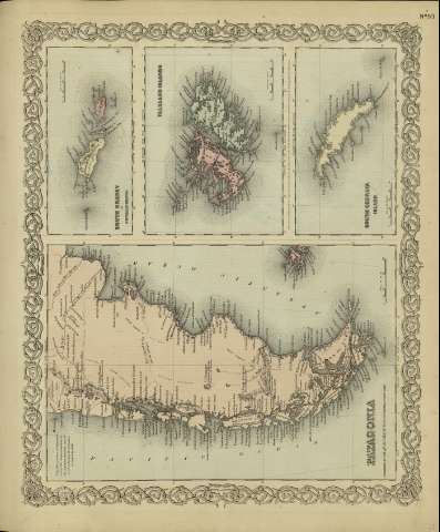
Falkland Islands


Section: Maps
Title: Falkland Islands / [drawn by George Woolworth Colton]
Author: Colton, George Woolworth, 1827-1901
Área de datos: Escala [ca. 1:2.893.516], 50 miles [= 3'2 cm] (O 62º--O 57º /S 51º00'--S 52º50')
Publication: New York : published by G.W. and C.B. Colton & Co., [1872]
Physical description: 1 mapa : col. ; 12 x 16 cm, en h. de 36 x 44 cm
Notes: Indica meridianos de origen: Washington y Greenwich ; Márgenes graduados.
Con: Patagonia ; South Orkney ; South Georgia Island.
Registros relacionados: En: Colton's General Atlas : containing one hundred and eighty steel plate maps and plans, on one hundred and nineteen imperial folio sheets. - New York : published by G.W. and C.B. Colton & Co. n 172 William St., [1872]. - Nº 93
Materia / lugar / evento: Mapas físicos
Malvinas - Mapas
Hierarchical place name: Gran Bretaña Islas Malvinas
Otros autores: G.W. & C.B. Colton & Co.
Títulos secundarios: MALVINAS (Reino Unido) (Islas). S. 1:2893516
UDC: 912:911.2]:551.42(829.1)'1872'
829.1
Type of publication:
 Maps
Maps
Derechos: