
A Survey of the City and Suburbs of Cork


Section: Maps
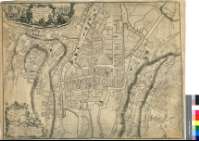
Title: A Survey of the City and Suburbs of Cork [Material cartográfico] / By J. Rocque
Author: Rocque, John, fl. 1734-1762
Edición: With All The New Improvement to 1773
Área de datos: Escala [ca. 1:2400]
Publication: London : Printed for Robt. Sayer, Map and Printseller, No. 53 in Fleet Street, 1773
Physical description: 1 plano ; 60 x 79 cm
Notes: Dedicatoria: "To the Right Worshipful the Major, Aldermen & Common council of this City"
Escalas gráficas de 900 pies británicos [= 11,3 cm], 40 irlandeses, 40 ingleses y 110 toesas
Relieve representado por normales
Título, escala y dedicatoria en cartelas rococó adornadas con angelotes, escenas portuarias y motivos religiosos. El río aparece surcado por barcas
Forma parte de la Colección Mendoza
Materia / lugar / evento: Cork (Irlanda) - S. XVIII - Planos
Irlanda - Divisiones territoriales - S. XVIII - Mapas
Lee (Irlanda, Río)
Género / forma: Planos de población
Hierarchical place name: Irlanda - Cork
Otros autores: Sayer, Robert, 1725-1794
Títulos secundarios: CORK (Irlanda). Planos de población. 1:2400 (1773)
UDC: 912:[314(084.3)](417)"1773"
417 Cork
Type of publication:
 Maps
Maps
Derechos: