
Kingdom of Hungary, Principality of Transilvania,...


Section: Maps
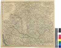
Title: Kingdom of Hungary, Principality of Transilvania, Sclavonia, Croatia, with a Part of Valakia, Bulgaria, Bosnia and Servia : from the Latest Surveys ascertained by Astronomical Observations [Mapa]
Área de datos: Escala [ca. 1:150000]
Publication: London : Printed for Robert Sayer N° 53, Fleet Street as the Act directs, 2d. June 1788
Physical description: 1 map. : col. ; 47 x 53 cm
Notes: Comprende la república de Eslovaquia, Hungría, Yugoslavia septentrional, Rumanía occidental y una pequeña parte del suroccidente de la URSS
Escalas gráficas de 80 millas inglesas de 69 1/2 al grado [= 8,5 cm], 8000 pasos geométricos, 13 leguas húngaras de 10 al grado y 20 leguas comunesde Alemania de 15 al grado. Coordenadas referidas al meridiano de Ferro (E 32°10'--E 42°50'/N 49°55'--N 44°00')
Orografia de perfil
Límites entre los paises y repúblicas representados diferenciados por color
Forma parte de la Colección Mendoza
Materia / lugar / evento: Mapas generales
Divisiones administrativas
Hungría
Eslovaquia
Yugoslavia
Rumanía
Otros autores: Sayer, Robert, 1725-1794
Títulos secundarios: IMPERIO AUSTRO-HUNGARO. Meridional. Mapas generales. 1788. 1:150000
UDC: 912:(1-2/-5)(439)(437.6)(497.1)(498)"1788"
439
437.6
497.1
498
Type of publication:
 Maps
Maps
Derechos: