
A New Map of Ireland : Divided int o Provinces, Counties


Section: Maps
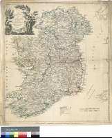
Title: A New Map of Ireland : Divided int o Provinces, Counties [Mapa] / By Thos. Kitchin geogr. Hydrographer to his Majesty
Author: Kitchin, Thomas, 1718-1784
Área de datos: Escala [ca. 1:781000]
Publication: London : Printed for Robert Sayer N° 53 Fleet Street, as the Act directs, 1 Augt 1786
Physical description: 1 map. : col. ; 64 x 56 cm
Notes: Comprende Irlanda e Irlanda del Norte
Escalas gráficas de 50 millas estatutarias británicas [= 10,3 cm] y 40 millas irlandesas de 54 1/2 y 14 "Poles" al grado [= 10,3 cm]. Coordenadas referidas al meridiano de Londres (O 9°10'--O 5°10'/N 35°12'--N 50°00'). Red geográfica de 1° en 1°. Orientado con lis en rosa de ocho vientos
Orografía de perfil
Tabla de signos convencionales para indicar poblaciones, caminos, carreteras y divisiones administrativas
Título enmarcado en paisaje vegetal
Materia / lugar / evento: Mapas generales
Divisiones administrativas
Irlanda del Norte (Reino Unido)
Otros autores: Sayer, Robert, 1725-1794
Títulos secundarios: IRLANDA. Mapas generales. 1:781000 (1786)
UDC: 912:(1-35)(417)(416)"1786"
417
416
Type of publication:
 Maps
Maps
Derechos: