
Kort over en Deel af Aalborghuus og Seiglstrup Amter samt...


Section: Maps
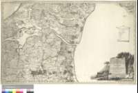
Title: Kort over en Deel af Aalborghuus og Seiglstrup Amter samt af Vendsyssel under det Kongl. Viidenskabernes Societets direction ved rigtig Landmaaling optaget og ved trigonometriske samt astronomiske Operationer pröved [Material cartográfico] / Reduceret fammensat og Tegnet af P. Harbae Aar 1791
Author: Angelo, Theodore Gottfried Nicolai
Área de datos: Escala [ca. 1:120000]
Publication: [Dinamarca] : Stukket af N. Angelo, Aar 1793
Physical description: 1 map. ; 52 x 85 cm
Notes: Comprende la parte meridional del condado de Nordjutlandia desde la ciudad de Lyngsa
Escala gráfica de 1 1/2 millas danesas de 18000 varas [= 9,2 cm]. Coordenads referidas a un meridiano que no se especifica (O 3°12'--O 1°33'/N 57°16'--N 56°43'). Recuadro geográfico de 5' en 5'
Orografía a trazos
Tabla de signos convencionales para indicar núcleos de población de distinta categoría, caminos, etc.
Título, autor y escala enmarcados en cartela de forma arquitectónica decorado con escena costumbrista y tabla de signos también en cartela a modo de pergamino
Forma parte de la Colección Mendoza
Materia / lugar / evento: Mapas generales
Nordjutlandia - S. XVIII - Mapas
Otros autores: Harboe, F.C.L.
Títulos secundarios: NORDJUTLANDIA (Dinamarca). Condado. Meridional. Mapas generales. 1793. 1:120000 (1791)
UDC: 912(489)"1791"
489 Nordjutlandia, condado-13
Type of publication:
 Maps
Maps
Derechos: