
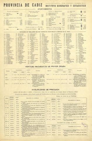
Cádiz


Section: Maps
Title: Cádiz / J. Mas Go
Área de datos: Escala [1:37.313]
Publication: Barcelona : [Alberto Martín], [entre 1900 y 1920]
Physical description: 1 mapa : col. ; 39 x 52 cm, pleg. en 39 x 26 cm
Notes: Figura impresa la firma del autor.
Indica coordenadas referidas al meridiano de Madrid: O 3º00'--0 1º19' /N 37º05'--N 36º00')
Indica relieve representado por normales.
Incluye leyenda de símbolos utilizados.
Incluye ilustración del escudo provincial.
Al verso, índice de ayuntamientos, nivelaciones y vértices geodésicos de primer orden.
Registros relacionados: En: España Regional. - Barcelona : Alberto Martin, [entre 1900 y 1920]
Materia / lugar / evento: Mapas generales
Cádiz (Provincia) - Mapas
Hierarchical place name: España - Andalucía - Cádiz
Otros autores: Rocafort, Ceferino, fl. 1912-1950
Dalmau, Casimiro, fl. 1910-1921
Títulos secundarios: CÁDIZ. Mapas generales. 1900-1920. 1:37.313
UDC: (460.355)
Type of publication:
 Maps
Maps
Derechos: