
Italien im maassstabe von 1:3700000 : [generalkarte]


Section: Maps
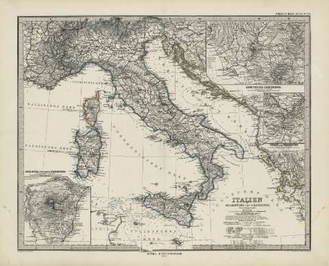
Title: Italien im maassstabe von 1:3700000 : [generalkarte] / von A. Petermann ; gezeichnet von H. Habernicht ; ger tochen von C. Stien u H. Stichart
Área de datos: Escala 1:3700000
Publication: Gotha [Alemania, R.D.] : Justus Perthes, 1879
Physical description: 1 mapa : col. ; 33x41 cm, en h. de 39x48 cm, pleg. en 39x24 cm
Notes: Coordenadas : E23 40'-E38 40'/N46 10'-N35 45'. Meridiano de Ferro. Constan ademas coordenadas segun el meridiano de París
Relieve : sombreado, batimetria
Leyenda de signos utilizados
Inserta : Der Etna und seine Ungeburg - - Rom und die Campagna - - Turin und Ungeburg in massstable 1:500000
Registros relacionados: En: Hand atlas : über alle Theile der Erde und über das Weltgebäude. - Gotha [Alemania R.D.] : Justus Perthes, [1879]. - N 30
Materia / lugar / evento: Mapas generales
Italia
Otros autores: Petermann, Augustus Herman, 1822-1898
Stieler, Adolf, 1775-1836
Habenicht, Hermann, (1844-1917
Stier, C.
Stichart
Perthes, Justus, 1749-1816
Títulos secundarios: Italia. 1:3700000
UDC: 912:341.222(45)'1879'
45
Type of publication:
 Maps
Maps
Derechos: