
A New Map of Derby Shire : Describing the Noblemen and...


Section: Maps
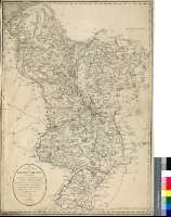
Title: A New Map of Derby Shire [Material cartográfico] : Describing the Noblemen and Gentlemen's Seats, Borough & Market Towns, Villages Canals, Rivers, Moors, Hills, Watering Places, with the Turnpike andCross Roads and Distances from Place to Place, &c. from an Actual Survey / by P.P. Burdett ; and Improved by John Andrews
Author: Burdett, Peter P., fl. 1786-1794
Área de datos: Escala [ca. 1:130000]
Publication: London : Printed for R. Wilkinson, N° 58 Cornhil, Publishes as the Act directs, 7, Sep. 1786
Physical description: 1 map. : col. ; 73, x 52 cm
Notes: Escala gráfica de 10 millas estatutarias inglesas de 69 1/2 al grado [= 12,1 cm]. Coordenadas referidas al meridiano de Londres (O 1°03'30''--O 2°02'10''/N 53°31'30''--N 52°40'00'')
Orografía por normales
Límites entre los distintos hundreds que forman este condado diferenciados por color
Indica los condados con los que limita, incluyendo datos sobre los mismos
Mapa sangrado en algunos puntos
Materia / lugar / evento: Inglaterra
Otros autores: Andrews, John, 1736-1809
Wilkinson, Robert, fl. 1785-1825
Títulos secundarios: DERDYSHIRE (Reino Unido) (Inglaterra). Mapas generales. 1:130000 (1786)
UDC: 912:(1-28)(420)"1786"
420 Derdyshire, condado
Type of publication:
 Maps
Maps
Derechos: