
A New Map of the County of Surrey : Laid down from an...


Section: Maps
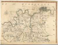
Title: A New Map of the County of Surrey : Laid down from an actual survey [Mapa] / by John Senex
Author: Senex, John, ca. 1678-1740
Área de datos: Escala [ca. 1:63360]
Publication: [London] : Printed for John Bowles at the Black Horse in Cornhil : Carington Bowles in St. Pauls Church Yard : & Robert Sayer in Fleet Street, 1729
Physical description: 1 map. en 4 h. ; 78 x 107 cm, en h. de 43 x 56 cm
Notes: Comprende el actual condado de Surrey y la zona suroccidental del Gran Londres
Escala nominal de una pulgada por milla y gráfica de 6 millas [= 14,7 cm]. Coordenadas referidas al meridiano de Londres (O 2°45'--E 1°00'/N 51°35'--N 51°09'). Orientado con lis en rosa de ocho vientos
Orografía a trazos
Líneas divisorias entre los hundreds que forman el condado, diferenciadas por color
Mención de venta
Título enmarcado en cartela decorada con motivos vegetales
Forma parte de la colección Mendoza
Materia / lugar / evento: Surrey
Gran Londres
Inglaterra
Otros autores: Bowles, John, ca. 1701-1779
Sayer, Robert, 1725-1794
Títulos secundarios: SURREY (Reino Unido). Inglaterra. Condado. Mapas generales. 1729. 1:63360
UDC: 912:(1-2/-5)(420/421)"1729"
420 Surrey, Condado
421-14
Type of publication:
 Maps
Maps
Derechos: