
Kongeriget Norge afdelet i finefure stifter, nemlig...


Section: Maps
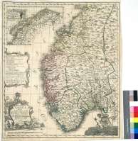
Title: Kongeriget Norge afdelet i finefure stifter, nemlig Aggerihuus, Charitianland, Berhenhuus og Tronhiem, samt underliggende Proustier [Material cartográfico] / Med Kongelig Allernaadigst Tilladelse og Bevilling forfordiget Aaar 1761 af O.A. Wangensteen Capitain ved det Norske Artillerie Corps ; T.A. Pingeling Junior Sculp
Author: Wangesteen, Ore Andreas, m. 1763
Área de datos: Escala [ca. 1:1040000]
Publication: [S.l.] : [s.n.], [1761?]
Physical description: 1 map. : col. ; 56 x 48 cm
Notes: Escala gráfica de 20 millas noruegas [= 14,2 cm]. Coordenadas referidas a un meridiano que no se específica (E 16°30'--E 28°30'/N 65°15'--N 57°34'). Red geográfica de 1° en 1°
Orogría de perfil
Divisiones administrativas diferenciadas por color
Tabla de signos convencionales para indicar núcleos de población de distinta categoría, límites, etc.
Adornado con una figura mitológica marina sosteniendo un escudo
Título y autor enmarcados en cartela rococó, decorado con paisaje, y tabla de signos, también en cartela, adornada con motivos vegetales
Forma parte de la Colección Mendoza
Inserta : "Nordland og Finmarken under Tronhiems Stift". Escala [ca. 1:2960000], 13 millas noruegas [= 3,25 cm]
Materia / lugar / evento: Mapas generales
Divisiones administrativas
Noruega - S. XVIII - Mapas
Género / forma: Cartas náuticas
Otros autores: Pingeling, T.A., 1727-1803
Títulos secundarios: Noruega. Mapas generales. 1761?. 1:1040000
UDC: 912:(1-35)(481)"1761"
481
Type of publication:
 Maps
Maps
Derechos: