
Tabula Geographica Imperi Russici exhibens stationes...


Section: Maps
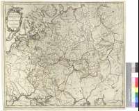
Title: Tabula Geographica Imperi Russici exhibens stationes cursuum et veredariorum publicorum [Mapa] / Comp. Tresskott 1760
Author: Trekot, I.
Área de datos: Escala [ca. 1:5190000 - 1:5670000]
Publication: [URSS : s.n.], 1760
Physical description: 1 map : col. ; 46 x 52 cm
Notes: Comprende el antiguo imperio ruso en la URSS Occidental con sus antiguas divisiones administrativas en en regiones y provincias. Señalándose además sus principales caminos y estaciones de posta
Escala hallada a partir 5 grados de latitud los paralelos 60° [= 10,7 cm] y 45°N [=9,8 cm]. Coordenadas referidas a un meridiano que no se especifica (E 26°--E 98°/N 65°--N 43°). Red geográfica de 5' en 5'
Orografía de perfil
Título enmarcado en cartela barroca
Forma parte de la colección Mendoza
Títulos secundarios: IMPERIO RUSO. Mapas generales. 1760. 1:5670000
UDC: 912:625.7:656.8:(1-2/-5)(47)"1760"
47
Type of publication:
 Maps
Maps
Derechos: