
The County of Northampton


Section: Maps
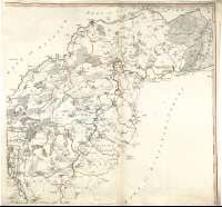
Title: The County of Northampton [Material cartográfico] / : as Surveyed and Planned by the late Mr. Thomas Eyre of Kettering ; Revised By the late Mr. Thomas Jefferys Geographer to the King ; and Engraved by William Faden 1779 ; ... Before whom this Map was then laid for their Observation and Correction (previous to its Publication) By the late Sir Thomas Cave Bart
Author: Eyre, Thomas, 1691-1758
Edición: Second Edition revised & corrected 1791
Área de datos: Escala [ca. 1:55100] (O 1°19'45''--O 0°09'00''/N 52°41'30''--N 51°59'50'')
Publication: London : Published as the Act directs... by William Faden, Geographer to the King, Corner of St. Martins Lane, Charing Cross, 1791
Physical description: 1 map. en 4 h. : col. ; 123 x 128 cm, en h. de 64 x 68 cm
Notes: Dedicatoria : "Is with all due Gratitude, Inscribed to the Rt. Revd. Dr. John Hinchliffe, Lord Bishop of Neterborough John Clark Esqr. High Sheriff and the following Gentlemen of the said County assembled at the Summer Assize 1775. Viz..."
Fecha de publicación más antigua de las que aparecen en el docuemento : "1779"
Escala gráfica de 5 millas estatutarias [= 14,6 cm]. Recuadro geográfico de 5' en 5'
Orografía a trazos
Tabla de signos convencionales para indicar ciudades, parroquias, diferentes categorías de caminos, molinos, etc
Diferencia mediante colores los límites entre los "hundreds"
Forma parte de la Colección Mendoza
Inserta : "Queens Cross..." ; "Geddington Cross..."
Materia / lugar / evento: Inglaterra - Divisiones territoriales - S. XVIII - Mapas
Northamptonshire - S. XVIII - Mapas
Género / forma: Mapas administrativos
Hierarchical place name: Gran Bretaña - Inglaterra
Otros autores: Jefferys, Thomas, ca. 1710-1771
Cave, Thomas, 1737-1780
Faden, William, 1750-1836
Títulos secundarios: NORTHAMPTONSHIRE (Reino Unido). Inglaterra. Condado. Mapas generales. 1791. 1:5510
UDC: 912(420-27)"1791"
420 Northamptonshire, condado
Type of publication:
 Maps
Maps
Derechos: